
1
/
of
1
Second Gear WNC
National Geographic Map - South Holston & Watauga Lakes #783
National Geographic Map - South Holston & Watauga Lakes #783
Regular price
$14.95 USD
Regular price
Sale price
$14.95 USD
Unit price
/
per
Low stock: 7 left
Couldn't load pickup availability
Shipping is not available for apparel & gear with the exception of gift cards. You may order online for free in-store pickup.
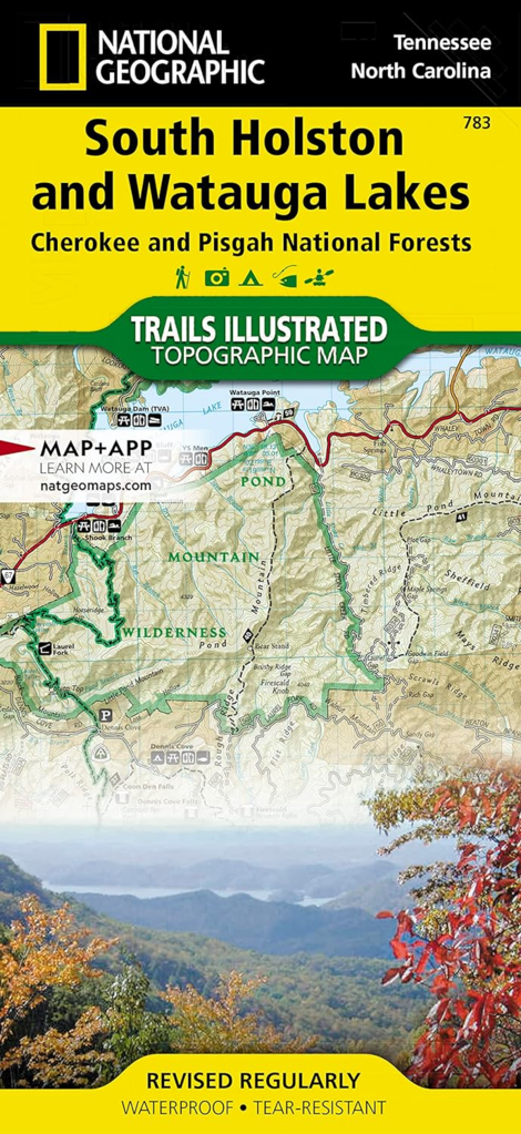
National Geographic's Trails Illustrated map of South Holston and Watauga Lakes is an essential travel companion for all outdoor enthusiasts seeking recreational opportunities in the mountains of eastern Tennessee. Expertly researched and created in partnership with the U.S. Forest Service, Appalachian Trail Conference and others, the map provides unparalleled detail of the area, from the northeastern corner of Tennessee to Erwin in the southwest. Many popular recreation points of interest in the Cherokee and Pisgah National Forests are covered, including Unaka Mountain, Pond Mountain and Big Laurel Branch Wilderness Areas, Roan Mountain State Park and Iron Mountains. Narrow down the best places to visit according to your needs and interests with handy activity guides. Extensive trail charts display each trail's location, mileage, difficulty level and designated usage whether you're traveling on foot, horse, mountain bike, or motorized vehicle. Mapped trails are also color-coded ac...
- FREE Returns on retail products within 30 days of purchase.
- FREE Returns on consigned products within 48 hours of purchase.
- Questions about this product?
- Call us at 828-258-0757
- We're here to help you find the gear you need! Call during business hours and speak to a real person - no robots here!
Share